A1 PUB CRAWL - part one - London to Peterborough
- Daniel Bates
- Mar 1, 2024
- 51 min read
Updated: Jul 27, 2024
Introduction
I am a Cartophile, a person who studies and loves maps and have done since the day my father gave me a 1980’s reader digest map book whilst doing a journey from Stevenage to Maidstone when I was a child. I studied that map book inside out and started to know where a lot of the towns were placed on the map. Then the roads linking them. I am sure my father gave me that book just to shut me up as a child. Since then the road map has changed a little in the United Kingdom, motorways in inner London have disappeared and changed into A roads to ease congestion, new toll road motorways in the Midlands and new bridges have been built across main rivers (also to ease congestion).

However one road which is known to everyone (if interested in Britain's road network of course), is the A1. The longest road on the islands which connects the English capital of London and Edinburgh, the capital of Scotland. Along some parts of the current A1, there is evidence to show that a road has always been here connecting London to the north, especially between Durham and the Antione Wall in Scotland, where the Romans built a road called Dere Street. The current A1 (and the motorway sections known as the A1(M)), I have driven up and down the A1 millions of times (especially the bit between Peterborough, Stevenage and London) and done the rest of the route up to Edinburgh on numerous occasions, even counting the roundabouts on the way. Did you know north of Stirling Corner in London, there are five roundabouts on the road (two in Biggleswade, one in Sandy, then the big (and awful) Black Cat roundabout (which connects to the A421 for Bedford and Milton Keynes) and then Buckden near Huntingdon. After that, there are 276 miles of NO roundabouts until Berwick-upon-Tweed on the English-Scottish border (then there are a few roundabouts on the approach to the Scottish capital).

So, the purpose of this blog post, the A1 Pub Crawl. I have to explain. It was a few days away from the crazy day known as Leap Year Day (February 29th 2024) and I had thought. I wanted a challenge which would combine my love of hiking, history, writing, exploring and drinking beers. I also live alongside the A1 in Stevenage and that was it, what about if I did a long walk alongside the A1 and tick off pubs on the way. I am a user and member on the app on my cell phone known as CaskFinder hosted by Cask Marque (where pubs with good ales pay to go on this app, it appears on a map, then members can go to this pub, buy an ale, scan the certificate which is from the Cask Marque headquarters and it ticks off the pub on the app….it is known as the world’s biggest pub crawl). It sounded crazy but whilst ticking off pubs on the app, I am also seeing new places and learning a lot of history. That was it, the challenge was set. 410 miles (660km) was ahead and plenty of quality ales to be drunk on the way.


Just to note, I won’t be doing this hike all in one hit. I have a wife and two children to support, I am sure my managers at my ‘real job’ wouldn’t want me to have two months off just to walk and get pissed and then there is the bank manager. A lot of money is needed. So I am doing this in sections starting off in London. I will be using the trains a lot to get back to where I finished off the last section and to get back to my base in Stevenage (or hotels if needed on the northern end of the route). Then there is the question of the A1 being dual-carriageway or turned into a motorway in sections along the route. To overcome this, in places I will be walking along the roads which used to be the A1 (but still called the Great North Road) which run alongside the modern-day A1 (and of course, the old pubs and inns are on the old sections as well). I will explain this as I go along.
Section 1 - the start (or finish) of the A1 at St Paul’s Cathedral to Angel (Islington)
In all my life, I was wrong. I always thought the A1 started at St Paul’s Cathedral in the City of London (to which there is evidence this may have been the case in the past or even at the Bank of England), but the official start point now is at the roundabout where the Museum of London is located which has turn offs for St Paul's Cathedral (to the south), the London Wall (heads eastwards towards Liverpool Street train station) and St Bartholomew's Hospital (to the west) which is kinda handy if I break a leg or something like that after 100 meters of walking after starting the hike.


A quick swift half of IPA at the Greene King managed pub at the Lord Raglan just a few meters south of the official start/finish of the A1 and I was off. I got all excited walking around the roundabout where the Museum of London is housed and found a plaque saying that a building next to the roundabout was the site of Cook’s Hall which was burnt down by fire in 1771. The original building was built around 1500 and even managed to escape the Great Fire of London. After being enlarged in 1674, a fire in 1764 partially destroyed the building and was rebuilt. Then a few years later in 1771 it was totally destroyed. Before anyone asks, yes, Cook’s Hall was a place where people learned to cook and cook for the rich in the local area.


Making sure I didn’t get hit by one of those lovely red double-decker buses, I was heading north on Aldersgate Street. There is no sign at the roundabout to say this road is the A1. Nothing at all but all the street maps and Google Maps state that this road is the A1. This part of the road is on the outskirts of the City of London, so I was already leaving the skyscrapers behind me. Aldersgate is named after one of the four gates which is located on the nearby London Wall, an medieval wall which encircled the area known as today, ‘the city of London’ and records of this are dated back to the 1300s. I reached Barbican underground station in the first 250 meters of the walk. In the past this station used to be called Aldersgate before the Barbican development in the area was being built after the Second World War. This area was totally bombed in the war by the Luftwaffe who were the aerial-warfare branch of the Wehrmacht. Nice fellows they were, not. At least, somehow, nearby St Paul's Cathedral didn’t get bombed by them, Prime Minister Winston Churchill made sure of that. At all costs, he said that the Nazi Germans must not bomb St Paul’s, otherwise this will make the British sad (something like that anyway).


The buildings along Aldersgate are an eyesore. They maybe amazing back in the 1950s or 1960s but look out of place with the modern City of London in the background. I wasn’t impressed. I kept on walking until I found a Shepherds Neame pub called the Old Ivy House. It is not on the Cask Marque app (I wish it was…hint hint Shepherds Neame), but I also tick off Shepherds Neame. I love their beer. They are one of Britain's oldest breweries located in the Garden of England, Faversham in Kent. My family are from Kent and I did live there for a short while in the mid 2000s in stunning places like Chatham, Strood and Northfleet with my ex-girlfriend at the time. However I spent a lot of time drinking with her old man, sometimes in places like Rainham, but most of the time, in Shepherds Neame pubs down in Faversham every Saturday night. Loved the pubs down there and I wish I discovered their ales a bit more sooner as I was a bit of a lager boy back then. I even drank a lot of Oranjeboom (the Dutch lager) in those times. Probably the only good part of that two year relationship with my ex. Anyways…..


After leaving the pub and having a half of the Cobnut, I just kept on walking. Aldersgate Street turns into Goswell Road. There was a shop here way back in the 1840s of a back and confectioner Tom Smith (1823-1869), who may have invented the Christmas Cracker. Another bit of history I found whilst doing research for the start of the A1 is that in this area, the first successful four-minute mile was run by James Parrott on the 9th of May 1770. He ran the whole mile length of Old Street (which crosses Goswell Road) to finish somewhere in the grounds of the Church of St Leonard’s in nearby Shoreditch. Time methods around this time after the invention of the chronometer by John Harrison were accurate enough to measure the four minutes correctly, & sporting authorities accepted the claim. However Old Street has an 11-foot downward fall and the record is not recognised by modern sporting bodies. As a runner I didn’t know this until I did my research. Learn something new everyday.


The road leads to a crossroad at Angel and I am now in the Borough of Islington. The road to the west of me heads down the hill towards Kings Cross, St Pancras and Euston’s station and is the main road to get out of the city if heading westwards. The road to the east heads towards Spitalfields and is the northern bypass of the City of London. The road is the A501 if anyone wants to know that fact. Straight over is where the A1 carries on and is also known as Islington High Street. This is where my walk on section one finishes but before I downed tools and walked down the hill to catch my train home, there is a pub called the Old Red Lion which is also housed in the fringe theatre, also named Old Red Lion Theatre Club which was founded in 1979.

The pub in itself is one of the oldest in London, having first been built in 1415 in what was then the rural village of Islington in open countryside and fields. A house called Goose Farm and some nearby cattle pens (for herds being driven to Smithfield Market) were the only structures to adjoin it, and St John Street (then called Chester Road) was a country lane. The Old Red Lion was rebuilt in 1899 adding two exits onto different streets. This gave the pub the nickname "the In and Out", since taxi passengers could avoid paying their fare by entering it through one door and disappearing through the other.


After an eventful 1.2 miles, I can’t wait to see what history, what pubs and different landscapes behold in front of me as I make my way towards Edinburgh on my made up pub crawl involving the pubs on the Cask Marque app. Next on route, the section between Angel and Holloway Road underground station.
Date: February 26th 2024.
Distance walked: 1.2 miles - 2km.
Distance to go to the finish at the east end of Princes Street, Edinburgh: 396miles/637km
Pubs on the way:
Lord Raglan - 61 St Martin's Le Grand (south of the roundabout).
Old Red Lion - 418 St John St (at Angel Junction).
Non-CM pubs on the way:
The Old Ivy House (Shepherds Neame) - half way along Aldersgate.

Section two: Angel (Islington) to Holloway Road underground station
Back on the underground using the Northern Line to get back to the point where I left off the previous weeks little pub crawl arriving at Angel, which is one of two underground stations named after pubs (the other being Elephant and Castle). This part of Islington known as Angel takes its name from the original 17th-century coaching inn which stood at number one, Islington High Street (on the junction with Pentonville Road where there used to be a tollgate for people wanting to use their horse and carts up the Great North Road). Built in 1639, rebuilt in 1819 and then at the turn of the twentieth century, it remained a pub until 1921 which then the Co-op bank arrived and took over (and remained here until 2020’s where it closed down recently and the building remains empty). In the past travellers would rest here overnight rather than risk the open land between Islington and the City, which was infested by highwaymen and other thieves. There were also large fields for farmers to rest their animals before the journey to Smithfield meat market near Farringdon. The Angel was rebuilt in 1819 and became a coaching inn, the first northward staging post outside the City of London. It became a local landmark and was mentioned in Oliver Twist by Charles Dickens, in connection with Oliver’s first meeting with the Artful Dodger: “it was nearly eleven o’clock when they reached the turnpike at Islington. They crossed from The Angel into St John’s Road”.


The area in which it was situated used to be called Merry Islington because from time immemorial it had been a great entertainment centre for Londoners. The Collins Music Hall, the Grand Theatre and the Philharmonic Hall were all situated here.


Next door to this building is the nearest pub to the junction (not on Cask Marque) which is now called The Junction, which used to be a Wetherspoons establishment but is now owned as an independent pub.

Walking down the high street towards my first pub, I noticed the raised pavements which are done in sections along this road. This is because (again) back in the day, horses and carts would come up and down this road all day, mud splashing about and making people dirty whilst walking. So raised payments were built so people wouldn't get dirty as much.

First pub of the day was the Steam Passage Tavern, a nice bar with some great decor (loving the street map display on one side of the bar of the local area). Great staff, clean, quiet (well, it was before lunchtime!) and had half of Bombardier’s Glorious English ‘to get the ball rolling’.


Next up I had to backtrack about 200 meters to tick off The York, which is owned by Nicholsons pubs. If I had the time, I would have had a nice Steak and Ale pie but not today, time was of the most important. Usually I would go for a Nicholson’s Pale Ale brewed by those lovely guys in St Austell, Cornwall but today I went for a half of Burrow’s Blonde Ale. Never tried it but it went down a treat.


Heading north along the A1 again and it wasn’t long before I was in the Fox on the Green, a nice sports bar and went for a half of Timothy Taylor’s Landlord, which wasn’t too bad, not always my first choice but as I was on a crawl with a few pubs today, I wanted to keep it easy.


Half way on today’s walk I went into The Vineyard, not a traditional London Pub. A spacious bar underneath an exposed brick arch, with a retro-style feel and outdoor space. Great place to watch sports, that's for sure. I was a bit unlucky here as they had problems with their cask ales so went for half of Amsterdam’s finest lager, Amstel.


The next pub is history. Not the pub itself but the music scene the pub associates itself with. The Hope and Anchor (which is owned by Greene King). Everybody who was anybody passed through these doors in the 'Seventies and 'Eighties: The Clash, The Cure, The Jam, The Police, Dire Straits, The Specials, The Stranglers, The Damned, Dr Feelgood, X-Ray Specs, Eurythmics, Elvis Costello and Madness to name just a few! U2 (famously in front of 8 people) and Joy Division (tragic frontman Ian Curtis having his first epileptic fit as he returned home from the gig), both had their debut London shows here!!
The venue gained such a high reputation that The Front Row Festival in 1977 (which featured XTC, Shakin’ Stevens and Tom Robinson) was recorded and released as a live double album by Warner, reaching No. 28 in the UK Album Charts. The Stranglers, Elvis Costello and The Saints also recorded live albums here, and Madness shot their music video to "One Step Beyond" in the place, Check it out here!. The venue bar even inspired a song – Splodgenessabounds' cult hit 'Two Pints of Lager and a Packet of Crisps Please' - apparently an ode to the futility trying to get served at the Hope! It reached No. 7 in the UK Singles Chart. This century has seen the likes of The Libertines and Enter Shikari also grace the stage.


Very shortly I was back on the A1 and landed up outside the underground station, Highbury and Islington (also an London Overground station and has National Rail services between Moorgate and Welwyn Garden City, Stevenage and Hertford if you wanted to know). The road layout has changed a lot since I rode as a passenger in my dad’s car when we used to drive from Kent back to our home near Stevenage in my childhood years. There used to be a roundabout here but now it's a two way street with half of the area being pedestrianised. There is a Wetherspoons pub here, The White Swan, which was originally the headquarters of the Working Men's Club & Institute Union.


Last pub of the day was The Famous Cock Tavern. Owned by Stonegate, It is a large single room pub with booths and larger tables at front street-side entrance, adjacent to Highbury and Islington station. Sports on TV screens dominate and can be loud, sometimes two different games are being shown.


I carried on walking up the A1 which is also known as Holloway Road and finished up at the underground station where I turned off here and walked past the mighty Arsenal stadium known as the Emirates (with the old stadium being nearby, Highbury, which was turned into apartments). Finishing up at Finsbury Park station and taking the train home back to Stevenage, feeling very happy (and slightly tipsy) after the several half pints I did today.
Date: March 4th 2024.
Distance walked: 1.9 miles - 3.1km. In total: 3.1 miles - 5.1km
Pubs on the way: (all Cask Marque/Caskfinder pubs):
Steam Passage Tavern. - Upper Street, Islington.
The York - 82 Islington High Street.
Fox on the Green - 1, Islington Green (located on the A1).
The Vineyard - 179 Upper Street, Islington.
The Hope and Anchor. -207 Upper Street, Islington.
White Swan - 255-256 Upper Street, Islington
The Famous Cock Tavern. -259 Upper Street, Islington.

Section 3 & 4 - Holloway Road to Potters Bar
Holloway Road, a 3km wide road which is one of the main shopping roads in North London, I continued my walk towards Edinburgh by walking very fast as I didn’t really enjoy this part of the walk. As soon as I got away from the hustle and bustle, I came to the area known for Dick Whittington, also known as Archway. I checked out the Archway Tavern (more on this later) however it is all about Dick Whittington.


The legend of Dick Whittington and his Cat is one of England's most famous folk tales and there is evidence to suggest that the pantomime version of the story, that still delights audiences today, was being played in much the same form in the 17th century. Dick was a poor boy who lived in the days of King Edward III and who came to London expecting to find the streets "paved with gold". Unfortunately, the best he could manage was employment as a scullion in the Kitchen of a wealthy merchant, Mr Fitzwarren. Bullied by the cook and plagued by the mice and rats that infested his attic, the poor lad was miserable. Hoping to deal at least with the latter of his problems, he bought himself a cat, which soon rid his room of the troublesome furry pests.

When Mr Fitzwarren offered his servants a stake in a cargo of merchandise that was bound for Barbary, Dick had nothing to venture but his cat. Fortunately, his employer accepted the feline investment and the ship set sail. But no sooner had it done so, than the cook's harassment intensified, causing Dick to run away. He had gone as far as Holloway when, exhausted and footsore with the uphill trek out of London, he sat on a stone to rest his legs. As he was catching his breath, the bells of Bow Church began to chime in the valley below, and Dick fancied that he heard them speak, urging him: "Turn again Whittington Thrice Lord Mayor of London". Intrigued, he decided to go back to Mr Fitzwarren's house, where he discovered that the ship had returned and with it had come a change in his fortunes. Apparently the Captain of the vessel had arrived in Barbary to find the King’s Palace overrun with rats. He loaned him Dick’s cat, which quickly dispatched the troublesome vermin, whereupon the grateful monarch purchased the entire cargo for a fantastical sum of money and paid ten times the amount again, to buy Dick’s cat. Thereafter, Dick Whittington’s fortunes went from strength to strength. He married his master’s daughter Alice and prospered immensely, crowning his achievements by becoming, just as the bells had foretold, three times Lord Mayor of London.
Richard Whittington (1358-1423) was the youngest son of Sir William Whittington, a wealthy Gloucestershire Squire, is actually a real life person. By his early thirties. he was a successful London merchant and had married Alice, the daughter of Sir Ivo Fitzwaryn. By the 1390's he was a master merchant, employing five apprentices and supplying expensive silks, cloth and textiles to the court of King Richard II. He had also begun loaning money to the Royal Exchequer and when the mayor of London died in 1397, the King showed his gratitude by appointing Whittington to the post. The citizens of London appear to have been more than satisfied by this, since the following year they re-elected him.


When Henry IV deposed King Richard II in 1399, Whittington continued to prosper and such was his importance as a source of ready cash to the Crown that by the end of Henry's reign, he had lent a total of £21,562. Since usury was illegal at the time, it seems that Whittington's only profit from these loans was the currying of Royal favour. He became mayor twice more, in 1406 and 1419 and served as MP for London in 1416. There is still debate as to the nature of the historical Richard Whittington's cat. He was buried in the London Church St Michael Pater Noster, and, although the site of his tomb is now unknown, his memory lives on in one of England's most timeless and well known folk tales. (Or the other question to ask is, was Dick Whittington two people, one a panto character with a cat, the other a nice old man in the high realms of London politics?).


Well, after checking out the stone which sits next to the Great North Road and the Whittington Park, the Whittington pub, the Whittington hospital and the statue of Dick Whittington’s cat, it was time to head further up the hill to the area known as Archway. One of the most iconic bridges can be found here known as Archway Bridge, also known as Hornsey Lane Bridge, which has been here since 1900 and made out of cast iron. However its also known as Suicide Bridge after a lot of people threw themselves of the bridge to end their lives. The final tipping point for locals was in 2010 when three people in three weeks threw themselves off the bridge so extra safety measures have been put into place. The bridge also marks the border of the London boroughs of Islington and Haringey. Near to the west of where I was standing is the famous Highgate Park cemetery where lies the graves of famous people such as Karl Marx, George Michael and Douglas Adams to name a few. I wanted to go and visit but I didn’t fancy paying for a tour to walk around the grounds.
Archway Road ends with a junction at the northern end of the road. The modern A1 carries on north-westwards towards Mill Hill and to the west of Barnet whilst the old A1, which is still called the Great North Road would be the turning I would take. I would carry on the old route for the Great North Road (which the road number is A1000 and would carry on northwards towards Welwyn Garden City). Just a couple minutes along the road, I came to my first two Cask Marque pubs of the day, The Old White Lion and The Bald Faced Stag. I am now in East Finchley. Not much goes on around here however there is music history here as I found out recently.


The Kinks. Heard of them? They were the London version of The Beatles during the 1960s I heard….personal opinion, I agree. I am not much into the music by those guys from Merseyside, even when I went to Liverpool for the first time over a decade again, checked out the museum on them etc, nope, it didn’t do much for me. The Kinks on other hand were just amazing, their lyrics, the tunes, the style, give me Kinks any day of the week. Earlier I went into the Archway Tavern, this is famous because the inside of the pub was used as a photograph as the cover of The Kinks tenth studio album, Muswell Hillbillies. The album is named after the Muswell Hill area of London (only a few clicks from where I was standing), where the band leaders (and brothers) Ray and Dave grew up and the band were formed there in the early 1960s. So I went in there for that reason alone.


As I walked along the Great North Road in East Finchley, there is a side road called Denmark Terrace (which is part of the main road Fortis Green). Anyway, at number 6, is the house where Ray and Dave Davies were born. Across the road is the pub, The Clissold Arms, where the brothers gave their very first musical endeavour. However in mid-1996 The Kinks gave their last public performance here during a party for Dave’s 50th birthday. How is that for music history?


Back on the Great North Road, it was time to hit up The Tally Ho (on Cask Marque of course) pub in North Finchley. The pub was built in 1927 on a wedge-shaped plot where Ballards Lane meets the Great North Road. It replaced the Park Road Hotel on the same site and was originally under the management of Charrington Brewery. The pub was named after the nearby Tally Ho Corner where in the 1820s and 1830s the Tally Ho Coach Company kept horses that were used for the first change of horses for the Birmingham mail coach.


After the Tally Jo I headed north again out of North Finchley through Whetstone where the Great North Road is getting wider in places and the houses have a bigger, more Victorian feel (and probably more expensive). Up the hill to Chipping Barnet, passing the site where Barnet Football Club used to play in a middle of a housing estate on the left (called Underhill), have some good memories of my team Stevenage getting positive results from there and to the right is the end of the Northern Line (High Barnet branch). This would be the point that I leave the London Underground behind. Just the East Coast mainline to hog alongside.

Chipping Barnet, situated on a top of a hill which is a slog to walk up, has been in the history books since 1070 but not much has happened around here apart from the Battle of Barnet (more of that in a moment). The tomb of Thomas Ravenscroft, an English musician, editor and theorist is buried in the church. However, the only recent history has to be about twenty years ago, a tongue-in-cheek movement calling for the name Barnet to be changed to "Barnét" began to gain the attention of the public and the national media, with many public road signs in the area regularly being altered to contain the accented character.

I did two pubs in quick succession, the first being the Ye Olde Mitre Inn which was established by 1633 and is probably the oldest remaining of the town's once numerous coaching inns. The Mitre primarily catered for the large number of stage coaches that passed through Chipping Barnet each day and a War Office survey of 1756 reported that it could provide 12 beds and stabling for 26 horses. In February 1660, General Monck of the English army is supposed to have stayed at the Mitre Inn on his way to London to restore King Charles II to the throne, after the Commonwealth. According to the Mitre's own legend, a bet was placed at the Barnet horse fair that a horse could not be ridden backwards up Barnet Hill, at the top of which the pub is located, but the rider was not able to collect his money as he was dismounted from his horse and killed after colliding with the pub's sign. The Ye Olde Mitre Inn is surely a lovely old pub which I thought I was stepping back in time and the range of ales was excellent. I sure hope I come back to this pub again in the future.


The other pub on the northern end of town is Ye Olde Monken Holt. This is the last pub in Barnet heading north (or the first pub in Barnet and London if coming from the north) and a pub has been on the site since 1869, although originally it was called 'The Bell' and was two small houses with two rooms downstairs and two upstairs. The Bell was really a retail shop and ran for around a dozen years until renaming itself the Monkenholt Arms, then from 1880, the 'Monken Holt, Ye Old'. It is known that there was a cell or chapel in Barnet where monks resided and the area of Monken Hadley may reference this. The earliest references note the Pryors of Hatfield as owners, but Richard Kefford was licensee of the Bell until Alfred White became licensee, in 1895 after the name had changed. The Barnet Brewery bought it in 1907 and whilst it dabbled with a change of name to simply 'The Monk', it reverted to its more traditional name in 2017. Again, another nice pub with its old-world cozy atmosphere and run by fantastic staff. A quick drink here and it was time to head north.


However, a few meters up the road there is an historic site to check out. The Battle of Barnet was fought on the morning of Easter Day 14 April 1471. It was an important battle in the Wars of the Roses between Edward VI and the Earl of Warwick (called the king maker).
The Wars of the Roses External link was a series of civil wars fought between two aristocratic families, the House of York and the House of Lancaster. King Edward IV and Richard Neville, Earl of Warwick, had been allies during the wars and their success had led to the overthrow of Henry VI (of Lancaster) and the crowning of Edward (of York) as king. Warwick expected that his friends and favourites would be rewarded in the new court with prestigious positions. But Edward decided to favour the friends and relatives of his wife, the Queen consort of England, instead. After much conflict Warwick drove Edward into exile and placed Henry VI back on the throne. Edward, who returned in March 1471 with an army of Burgundian mercenaries, marched on London and took Henry prisoner.


The armies of Edward and Warwick met for the last time at Barnet at a place called Gladmore Heath. No one is sure where Gladmore Heath was, as the name has long ceased to be used. Many believe that the battle was in and around Hadley. The surrounding area is protected as London’s only registered battlefield site. Early in the morning of the battle, there was a thick fog. The armies engaged and one of Warwick's commanders succeeded in routing one of the flanks of Edward's army, and pursued them back to Barnet. But while they were away, the push of battle swung the armies around, and on returning they mistook the badge of another of Warwick's commanders (a star with streams of light) for the badge of their enemy Edward (a sun with rays). They attacked their own side, which panicked and fled. Warwick lost the battle and was killed.


Going north, I was in the countryside. Away from the London urban area. Fields and trees were aplenty. I walked through a small village called Bentley Heath and stopped here at the first pub in Hertfordshire (or last pub before heading into London), The Duke of York. The building itself used to be a coaching inn for horses and carts to stop off during their journeys. The origin of the name of the pub, The Duke of York, was first created in 1385 for Edmund of Langley, the fourth surviving son of King Edward III. Unlike many titles, this one has frequently died out due to general heirlessness, but it has been resurrected many times over - eleven to be precise. Indeed, the current Duke of York himself has no male heirs: the fact that the dukedom has rarely passed from father to son has led to the belief that the title is cursed. Of the fourteen dukes to date, five have died childless and six became king only after the death of an elder brother. The title has ever since been passed to the second son of the British monarch of the time. I really like this pub, spacious, clean, great staff, and above all, a great range of beers from local breweries.


The next landmark I walked past was the M25, London’s orbital road which has been here since 1986. I call it London’s number one car park. Potters Bar came very quickly. With the looks of the buildings and shops along the high street, I thought I was still in a suburb of North London. The Cask and Stillage would be the last pub today and was bustling with people who had just finished work. After this, it was time to head to the train station nearby to end this section of the walk along the Great North Road.


Pubs visited on this section:
The Whittington Stone - Cask Marque
Archway Tavern - Cask Marque
The Old White Lion - 121 Gt North Road, East Finchley - Cask Marque
The Bald Faced Stag - 69 Hugh Road, East Finchley - Cask Marque
The Clissold Arms - East Finchley.
The Tally Ho - 749 High Road, North Finchley - Cask Marque
Ye Olde Mitre Inn - 58 High Street, Chipping Barnet - Cask Marque
Ye Olde Monken Holt - 193 High Street, Chipping Barnet - Cask Marque
The Duke of York - Bentley Heath, Hertfordshire.
Cask and Stillage - 19 High Street, Potters Bar - Cash Marque.


Date: March 11th and 14th 2024.
Section 5 - Potters Bar to Roebuck (Stevenage)
I did this section over two days (Potters Bar to Hatfield and then back the next day for Hatfield to Roebuck, the southern gateway to Stevenage) was a quick and speedy affair. My walking speed was at my fastest. Heading out of Potters Bar I was back in the Hertfordshire countryside and walking past a lot of houses which are probably worth one or two million pounds, with their huge driveways, fountains and six bedrooms. That was Brookmans Park village. Before I knew it I was in a village called Bell Bar, where there used to be a tollgate here back in the day for the horse and carts. The only interesting thing to note here is that the road used for the horse and carts vers off here and into the grounds of nearby Hatfield House, a huge stately home. I wasn’t going to pay the entrance fee to walk on a bit of tarmac or have I got the time going around the house looking at paintings. Maybe another day. However I wondered if the tree was still in the grounds of Hatfield House. What tree, well from ancient times where Elizabeth Tudor was sitting underneath a tree, eating an apple and was told by one of her loyal servants that she was to become Queen, after the death of her sister, Mary in 1553 (and as she had no children, well, the throne was passed onto Elizabeth).
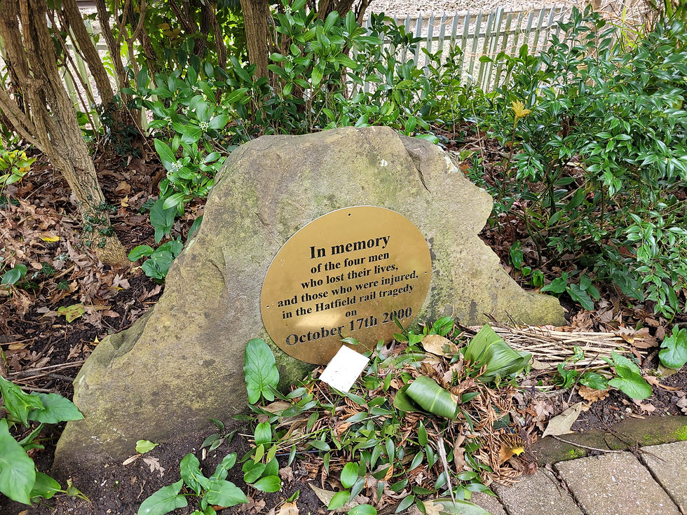
I stuck to the Great North Road where I was walking alongside the East Coast mainline. It is on the outskirts of Hatfield I came across the memorial to the four people who died in the Hatfield train crash back on 17th October 2000 which is still fresh in my mind after all the press coverage back then. I have always wanted to come to the memorial but never made the time. Well, that changed today. Located in a small piece of woodland, I walked in, saw the plaques, some recently laid flowers and took a moment to reflect. I turned around and noticed a young scruffy, unshaven twenty year old man smoking a fag and had four cans of Holsten Pills next to him. Welcome to Hatfield.
My short walk finished at the station (after a quick swift half in the Great Northern pub across the road), however I was back again later in the week. This time I headed across the road to an area known as Old Hatfield. It's called that now because before the late 1940s, Old Hatfield was Hatfield. After the Second World War, the new town act came into force by the UK government where new towns circling London were to be built, so Hatfield was one of those alongside Stevenage, Basildon and Harlow to name a few. I am going to be frank here, I am not a big fan of Hatfield. I know it well. I think the best way to describe the town is by watching the film ‘The Martins’ by Lee Evans and Kathy Burke from the early 2000s. That really sums it up (not all of Hatfield is bad and not all the people of like the Martins).


However I liked Old Hatfield. It was quiet, nice, older buildings and has history. Of course there is the entrance to Hatfield House but what interested me was the Eight Bells pub on Fore Street. Not on my Cask Marque list but this pub had history. Shame I was here a few hours before opening time (so I will go back for a quick drink someday as it's across the road from Hatfield train station). The Eight Bells is known for two things. First, the English author Charles Dickens stayed here and based a part of his story, Oliver Twist here where the character Bill Sykes was hiding out after murdering his mistress Nancy. Charles Dickens stayed here on the 27th December 1838 and the Eight Bells is one of three pubs featured in the novel, the others being the Black Swan Inn near Chertsey Bridge in Surrey and The Old Star on Richmond Hill.


The other reason is the fun historical fact. The Great North Road was known for having highwaymen along the route and a lot of horses and carts got robbed by them. One famous person who was excellent at doing this, was Richard ‘Dick’ Turpin and I was going to get to know him for at least the journey from London to Yorkshire on this road. Richard Turpin was a real man, but the stories about his adventures and his horse, Black Bess, maybe not real. But it has captured the minds of people and has gone down in folk law. At the Eight Bells pub, legend has it that Turpin mounted a daring escape by jumping out of a window onto his horse and escaped. Eventually Turpin was caught and executed by hanging at the age of 33 on April 7th 1739. His grave is in York. More of Turpin to come.


Heading north out of Hatfield, the old Great North Road is very mismatched. The old track for the carts is now built on by industrial estate, a Tesco supermarket, a horrible motorway junction (no.4 on the A1(M)) and the road to Welwyn Garden City. However back on track at Stanborough, I didn’t take the Great North Road which was built for cars and ran alongside the motorway, I took Brocket Road, which is a road built on the old road for horse and carts. This bends off a mile down the road into Lemsford village (turning where Saint John the Evangelist church is) and I took in the grounds of Brocket Hall to the left of me. Lemsford is a nice pretty village situated on the River Lea and has a mill in the heart. Lemsford Mill is one of four mills in the area and recorded in the Domesday Book of 1086.
Lemsford had a lot of pubs in the day but only one survived (and was still shut when I arrived at the village), the Sun Inn. Last year the most famous pub with history closed down, ‘The Long and Short Arm’ due to financial problems which was a shame. However, the old Great North Road for tracks would run alongside the grounds of this pub and headed northwards, however today, the old road lies within private grounds and no visitors are allowed.


Out of Lemsford and I was back on the Great North Road at Junction 5 of the A1(M), no, I didn't walk on the motorway but the old Great North Road which runs alongside the motorway. This is probably the only part of the route where the A1(M) and the old Great North Road runs alongside each other. However this is going up (or down depending on what direction people are traveling in) the infamous Digswell Hill where during bad weather like heavy snow, traffic comes to a stand. At the top of the hill lies a village to the west, Ayot St Peter, to which I took a detour. Over the motorway, first left and I was on the old Great North Road for horse and carts again. I walked over 300 meters until the road came to a dead end. This was the otherside of the private grounds where I mentioned earlier in Lemsford that the track used to go through. I looked over the fence and can still see the track however a lot of moss, weed and grass is burying it. Whilst here, there is a pub called the Waggoners and it was opening time. Time for a quick pint and whilst here, I got to know the barman who was from Cannes in France. The pub was also a French restaurant and after getting to know him, the business and what's on the menu (and taking a great look in detail at all the beers and the wine menu), I am pretty sure me and the wife will be back here for some fine dining. We love France and often go there. So a bit of France closer to home wouldn’t go amiss.


Down the Digswell hill next into Welwyn village, where I had the joys of having half pints in the Old Red Lion, The Streamer, The White Hart, The Wellington and the Rose and Crown (not all of them are on Cask Marque but I was quite thirsty and wanted to get to know the village, as its a village I am not well familiar with despite living locally). The village lies on the banks of the River Mimram and found out the village’s name is derived from Old English Welig meaning Willow. However the village has its historic moments as well. Leaving the village I walked past Rose Cottage on Church Street, where it had a grey plaque outside stating that Vincent Van Gough, the famous painter who chopped a part of his ear off because he was a bit crazy, walked from London to Welwyn to visit his sister who was staying in this cottage.


On the outskirts of the village at Junction 6 of the A1(M), lies the Welwyn Roman Baths, which are remains of a third-century bath house). Many Roman artifacts have been found in this area and remains of several Roman villas. However the Roman Baths were uncovered by a local archaeologist Tony Rook and took about ten years to uncover the whole site. Shortly after the excavation was completed, the Ministry of Transport announced the route of a new motorway (the current A1(M)). The motorway was built on the TOP of the Roman Baths. Don’t worry, the baths are preserved in a vault where visitors have to walk down a tunnel to reach the site. I was fortunate to visit the site with my family a couple of weeks beforehand as it's only open on Saturday lunchtimes during school term time, and I found out so much history here. The children even enjoyed themselves.


I was still in Dick Turpin territory and the village of Oaklands had the North Star pub. I went instead and found out that this pub, to which Dick Turpin was known to hideout here a lot, had nothing on display. I was gutted. The pub sign had an old railway locomotive but otherwise, no Turpin history was to be found here. However there are two roads nearby named after him. That's all I got.


After walking up the famous Madley Hill, I made it to Woolmer Green, checking out Red Lion pub but also had a great time at The Chequers where I got to speak to the staff there (whilst drinking another fine half pint of ale). After talking about my adventures of the Great North Road so far, dressing up as Dick Turpin with my drink etc, they pointed out a large mural of Dick in another room and told me a couple of rooms upstairs are named after him and Black Bess. This pub was also a Dick Turpin hideout so I was glad to stop here.


Knebworth was next. Pronounced without the ‘K’. The old name of the village comes from the Old English (and was mentioned in the Domesday Book) as Chenepeworde. I think I prefer Knebworth. Try and get the old name announced on station announcements at the nearby train station. Knebworth is famous for its grand house next to the A1(M) junction seven and hosts a lot of outdoor concerts. I remember Oasis and Robbie Williams performing there, but in the 1970s and 1980s, the grounds of Knebworth House were rocking with the likes of The Rolling Stones, Queen (their concert here in 1986 was the last with Freddie Mercury), The Beach Boys and Elton John to name a few.


However, the only interest I had in the village was ticking off its only pub, The Station which of course lies next to the train station. (However there is another pub in the village of Old Knebworth which lies up the hill to the west of Knebworth). I love this pub. Great range of ales and lagers and great chats with the locals and landlord. I decided to stay for a few. They even had Shepherd Neame’s beers on draught here, and for those who know me, I love the beers from Britain's oldest brewery based in Faversham, Kent.
It was time to move on, up and down the hills of the Great North Road and into modern day Stevenage, Britain's first new town. I finished the walk at Roebuck and it is famous for the Roebuck Inn, another Dick Turpin hideout. These days, the inn closed down and is now an Indian restaurant. But I did see an old sign outside with the words, Turpin’s restaurant. After the walk, I ventured into Broadwater for a Cask Marque (but with the Beer Marque sign on the app) pub called Our Mutual Friend. I haven’t been here since my late teens, and it hasn’t changed one bit. With Stevenage FC memorabilia above the bar (as the ground is a stone's throw away from here), I ended up staying here for over an hour, speaking to friends I haven’t seen in years. This is one of the better pubs in my hometown and I am sure I will be back shortly.


Puns done on this leg of the Great North Road:
The Great Northern - Hatfield
The Waggoners - Ayot St Peter
The Old Red Lion - Ayot St Peter - Cask Marque
The Steamer - Welwyn
The White Hart - Welwyn
The Wellington - Welwyn
The Rose and Crown - Welwyn
The North Star - Oaklands
The Chequers - Woolmer Green
The Station - Knebworth
Our Mutual Friend - Broadwater, Stevenage - Beer Marque
Other pubs passed on this leg but not drank in whilst on the walk:
The Eight Bells - Hatfield
The Horse and Groom - Hatfield
Red Lion - Hatfield
The Wrestlers - Hatfield
The Crooked Chimney - Lemsford
The Sun Inn - Lemsford
The Tavern - Welwyn
The Red Lion - Woolmer Green


Date: March 15th and 21st 2024.
Section 6 - Stevenage
Ah, Stevenage, my home town (well, I was born and bred in nearby Hitchin but I always preferred Stevenage over my birth town and have lived in the town for over ten years now). Starting off in Roebuck at the Roebuck Inn, I headed north along the London Road through the retail parks of Roaring Meg and Roebuck (whilst also skirting the side of Monkswood retail park). The old Great North Road for the horse and carts diverted from Roebuck Inn towards the present day site of Wickes, and then going across the present day dual carriageway which leads up to the current A1(M), passing M&S Food Hall and rejoining near the Post Office sorting office. At this end of the London Road, there are six small hills, which are a collection of Roman barrows. They are classed as an Ancient Monument and are protected by law and they also form the largest surviving Roman Barrow group in England. Their origin and purpose has been the subject of much speculation. Local legend holds that they were the work of the Devil, who, sitting one day looking down on the Great North Road, began to amuse himself by heaving clods of earth at the passers-by. He missed six times and in a temper threw a seventh clod over his shoulder, hitting the spire of Graveley church and knocking it askew. The spire is crooked to this day. The holes in nearby Whomerley Wood show where the Devil dug out his missiles, and the six failed shots lie in a line alongside the road and form the Six Hills. The Six Hills are almost certainly Roman burial mounds, dating from about 100 A.D., and probably mark the cremated remains of a wealthy local family. The ashes would have been placed in a container along with objects for use in the next world.


Next up is Stevenage town centre, the heart of the UK’s first new town to be built after the Second World War. It has seen better days with people shopping for their goods online and moving away from shops. The town is half empty and what is there is a lot of food outlets and cheap electronic shops which no sod goes into. It is a shame as Stevenage is a great commuter town. Also when the town was being built, most of the old Great North Road has gone, but some of it still remains like the track next to the police station which goes over a bridge (which has a cycle track underneath). The only other piece to survive is from the retirement homes (which face opposite the police station on Lytton Way), passing the brand new bus station, the Gordon Craig Theatre and then it turns into a cycle track to the main entrance of the Tesco superstore. Again, it disappears as Tesco’s car park and the dual carriageway next to the petrol station has been built on top, but reappears on the other side as the main high street which goes through Stevenage’s old town.


Lets talk about pubs before more history. The first pub I came to is in the town centre, the Old Post Office which has only been here about ten years. But the pubs on the high street are worth talking about. Second one was The Chequers, then I did the Marquis of Lorne, Red Lion, The Drapers Arms (which is a modern pub I have to admit), The Mulberry Tree, then across the road is The Standing Order (the Wetherspoons of the town), and last off I did the The Broken Seal by Six Hills Brewing which is their tap room which to be honest, is just off the Great North Road on a side street, and not bad beer to be honest. The High Street also has the Coach and Horses, The Old Town Bar, the bar at the Cromwell Hotel to note. However a few more have closed down over the years and I think legend from my father and others claim that the street had thirteen pubs at least. Great for a stag do or a pub crawl.


Going back to the history, Stevenage's prosperity came in part from the Great North Road, which was turnpiked in the early 18th century on the site of the present day Marquess of Granby pub (which was the last pub I did on this walk, more shortly). Many inns in the High Street served the stagecoaches, twenty-one of which passed through Stevenage each day in 1800. During the 17th and 18th centuries, the road now known as Six Hills Way was the haunt of highwaymen who would use the ancient burial mounds as a hiding place. James Whitney, the namesake of the Highwayman pub in Graveley, was hanged at Newgate in 1693 for robbing travellers in this area. Whitney, a Jacobite, was born in Stevenage c.1660 and was apprenticed to a butcher in Hitchin before opening an inn in Cheshunt. Due to the failure of his business, Whitney began robbing wealthy travellers and by 1690 he had a gang of over 50 men.

On 10 July 1807, the Great Fire of Stevenage destroyed forty-two properties in Middle Row (a side street of the Great North Road in the Old Town), including Hellard's almshouse of 1501. The fire is believed to have been started when a young girl employed as a chambermaid at one of the coaching inns emptied embers from the fireplace into the street. Sparks from the embers ignited the thatched roof of a nearby wheelwright's shop, and quickly engulfed the other timber framed buildings in the north end of the Old Town due to a strong North wind. The conflagration was only stopped from engulfing the entire street by demolishing a house to serve as a firebreak. After the fire was extinguished by Stevenage's volunteer firefighters using a hand-operated fire engine made in 1763, the houses and inns were rebuilt with brick facades and tiled roofs.


Another piece of history which involves a coaching inn in Stevenage’s Old Town is about a man called Henry Trigg. Trigg was a prosperous grocer with a twin-gabled shop in Middle Row, Stevenage, Hertfordshire, as well as a number of other properties. He was a churchwarden, an overseer of the parish, and an important man locally. It is said that one night, he and two friends witnessed grave robbers at a local graveyard, and they vowed to make sure that this would not happen to them. Trigg stated in his will that his body should be committed for a minimum of 30 years to "the West end of my Hovel to be decently laid there upon a floor erected by my Executor, upon the purlin for the same purpose, nothing doubting but that at the general Resurrection, I shall receive the same again by the mighty power of God." According to Gentleman's Magazine of 5 Feb 1751, Trigg's will stated that he supposed that he would return to life after 30 years and then his estate would revert to him, and that he ordered that the barn be locked with the key inside his coffin so that he could let himself out. Shortly before he died, Trigg had negotiated with the parish authorities to rent his barn as the town's workhouse.
Trigg died in Letchworth, Hertfordshire on 6 October 1724 before renovations could be carried out on his barn. He never married, and his heir and executor was his brother the Reverend Thomas Trigg. The will stated that, if Thomas was reluctant to carry out the request, then everything bequeathed to him would go to their brother George Trigg or, if he refused, then to Trigg's nephew William Trigg. Therefore, his remains were placed in a lead-lined coffin of oak and pine and hoisted into the rafters of the barn behind the shop, about 10 feet (3.0 m) above the ground.

The coffin became a tourist attraction, and copies of the eccentric will were sold. It has been described as "a very unusual and possibly unique example of a coffin being placed above ground in the roof of a building", and Trigg was said to be "challenging priestly authority with this untraditional burial; it is a very early instance of a fear of grave robbing, which was a late-C18/C19 anxiety; and Trigg's eccentricity became the focus of a small cult of tourism." The will was also published under the title "Eccentric Will" in The Christian's Penny Magazine of 21 February 1835.
In 1769, Trigg's niece Ann died, leaving provisions in her will for Trigg's bones to be interred in a churchyard; but this never happened. In 1774, the house was converted into the Old Castle Inn, which used the coffin as a tourist attraction. There were several fires in the 19th century, most notably the Great Fire of 1807 (as mentioned earlier), but Trigg's barn and coffin survived. A carpenter is said to have stolen a tooth and some hair during repairs to the coffin in the early 1800s. In 1831, Mr Bellamy was landlord of the inn; he opened the coffin and reported that the hair on the skull was "in a perfect state of preservation". In the 19th century, the coffin was deteriorating so a new one was made, bound with iron bands, and Trigg's remains were returned to the rafters. In 1906, the East Herts Archaeological Society visited the coffin and reported "about two thirds of a male skeleton".
During World War I, Commonwealth soldiers billeted in Stevenage are reported to have stolen the bones. It was rumoured that the soldiers could be persuaded to part with the bones for a fee but supplemented the supply with the help of a local butcher. A letter to a local newspaper stated that in 1917, a resident went into the barn to look in the coffin and found horse bones. A nearby horse-riding school explained that copies of the will were still being sold and, if word got around that the coffin was empty, it could cause a drop in revenue. The coffin was temporarily removed in 1999 when the barn was refurbished and the owners at the time, National Westminster Bank, demanded that any bones were removed. Some reports say that the coffin was found to be empty, though others state that the Letchworth undertakers who restored the coffin buried any remains. Trigg's plan had ultimately failed. A plaque was erected to commemorate the story.
In 1964, renovations were being carried out on a property in Middle Row, and a Fred Usher claimed to have seen a man about 5 feet 8 inches (1.73 m) tall, shabbily dressed in overcoat and gaiters, disappear through the solid brick wall in front of Trigg's barn. A reporter from the Nationwide TV show visited in 1975 but failed to get Trigg's ghost to appear. It is said that Trigg's ghost wanders the old house searching for his remains.
How spooky and crazy is that story guys? Talking about craziness, I wanted to add this one in which is about the village of Walkern (to the east of Stevenage). Walkern is noted as the home of Jane Wenham, who in 1712 was the last woman in England to be convicted of witchcraft and condemned to death (although the sentence was not carried out). I just wanted to shove that in there.

As well as Dick Turpin and loads of other highwaymen using the Great North Road through Stevenage, I leave the history lesson at that, and finished my pub crawl at the Marquis of Granby near the Lister Hospital. Can’t wait for the next part of the walk.


Pubs done on this leg of the Great North Road:
28 - The Old Post Office, Stevenage Town Centre (on CM)
29 - The Chequers, Old Stevenage (on CM)
30 - The Marquis of Lorne, Old Stevenage (on CM)
31 - The Red Lion, Old Stevenage (on CM)
32 - The Drapers Arms, Old Stevenage (on CM)
33 - The Mulberry Tree, Old Stevenage (on CM)
34 - The Standing Order, Old Stevenage (on CM)
- Broken Seal Tap Room (Six Hills Brewing), Old Stevenage.
35 - The Marquis of Granby, Old Stevenage.
(on CM) = On CaskMarque/CaskFinder

Date: April 3rd 2024.
Distance walked: 3.1 miles - 5km. In total: 39.2 miles - 63.3km
Section 7 - Stevenage to Sandy
A full day of hiking planned for this stage of the Great North Road. Returning to the Marquis of Granby in Northern Stevenage, it wasn’t long I was walking through Forster Country, however this part of the Great North Road is rapidly changing. A brand new housing estate is being built which has totally ruined the landscape around here and is now joining onto the village of Graveley which was my next stop on this crazy walk. The Wagon and Horses was quickly ticked off before continuing north. The next village is Jack’s Hill.


However, nearby is a village called Weston which is famous for the local legend of Jack O’Legs who is a giant but was also an archer like the famous Robin Hood of Sherwood Forest. Jack also used to rob the rich to give to the poor and is supposed to be buried in the local churchyard. The legend is that Jack lived in a cave in a wood in Weston. One year there was a poor harvest, the bakers in Baldock raised the price of flour. Jack got angry, ambushed the bakers and gave the flour to his friends in the village. The bakers got pissed off, caught him and blinded him. They gave him one final wish. Jack asked to be pointed in the direction of Weston so he could shoot an arrow with his bow and said where the arrow landed, that is where he will be buried. The bakers gave him a huge bow which no one else could pull. The arrow landed into the churchyard in Weston, three miles away (he fired it in Baldock) and this is where he is buried.


The legacy of Jack O’Legs, well, there is a grave in the churchyard where two stones are 14 feet (4.3 meters) apart which mark the head and foot of Jack’s grave. The cave is located in nearby Weston Wood and on the Great North Road, where I am walking through now is the hamlet of Jack’s Hill. There is a storyboard sign on Weston village green and the Tring Brewery has an ale named after the legend. Thought I mention this story while I have a quick swift half at the pub located here known as The Highwayman (another pub known for the likes of Dick Turpin to hide out in and rob the passing of the horse and carts back in the day).


Baldock eventually came and there are some pretty good pubs here, The George IV was the first on the outskirts of town but most are located on the High Street, Old White Horse and White Lion I checked off however there are a few others which makes Baldock a great small town to drink in. It's a sleepy historic town, nothing much happens here and the connection I have here is that my parents now reside here (to which I did stop for a chat and gave my feet a rest).
The story behind the naming of Baldock fascinates me. Founded by the Knights Templar (they were a military order of the Catholic faith and one of the wealthiest and most popular military orders in Western Christianity. They were founded in 1119AD, headquartered on the Temple Mount in Jerusalem and existed for nearly two centuries during the Middle Ages), in the 1140s, Baldock got its name from the old French name for Baghdad, Baldac. While Damascus was the farthest location of Templar military activity during the Crusades, they would have been aware of the significance of Baghdad, which was widely regarded as the most prosperous market in the world. Perhaps the Templars hoped that the name would confer a similar prosperity on their own market town in England. Founding contemporaneous documents use the spelling Baudac, but it is first recorded as "Baldac" in the Pipe Rolls of Hertfordshire in 1168.


Leaving Baldock behind, the Great North Road carries on at the end of the nearby A1(M) and continues north towards Biggleswade. This section of the Great North Road I would not walk as it is very unsafe for pedestrians, well, there is no path alongside the road. So I diverted across the rolling hills of North Hertfordshire along bridle tracks, country lanes and public footpaths through Newnham, Hinxworth (another pub here ticked off) and Edworth before rejoining Biggleswade in the south of the town.


Biggleswade seemed forever to reach the town centre. The London Road was full of beautiful large Victorian houses but I was seriously getting bored of this road. However the walk was split on this road with a visit to the Yorkshire Grey pub for another quick tipple. The town centre is very historic with lots of old buildings and the White Hart was definitely one with history, dating back to the 1630’s and is a large, half-timbered building, which make this the second oldest building in the town as well as being the oldest pub. After checking out a few other pubs, it was time to head north again.


Below: Photos from The White Hart in Biggleswade.


Again, not touching the Great North Road from Biggleswade to Sandy via Beeston due to safety reasons, so I did the walk through Biggleswade Common, crossing the River Ivel, passing the RSPB reserve before arriving into Sandy by the train station where the walk ended today (and where I will restart for next time). However I carried on into town to the Queen’s Head where I met a fellow beer-loving instagram influencer and had two pints there before checking out the Sir William Peel and The Bell before taking the train home to Stevenage. The three pubs I checked out are fantastic and have their own thing going on, but since my last visit to the town over ten years ago (my grandmother and step-grandfather lived in the town in the last years of their lives), the pub and eating scene in the town has got better by the looks of it. Can’t wait to restart the journey again.


Pubs done on this leg of the Great North Road:
36 - The Wagon and Horses, Graveley (on CM)
37 - The Highwayman, Jacks Hill (on CM)
38 - The George IV - Baldock (on CM)
39 - White Lion - Baldock (on CM)
40 - Old White Horse - Baldock (on CM)
The Three Horseshoes, Hinxworth (on CM)
41 - Yorkshire Grey, Biggleswade (on CM)
42 - White Hart, Biggleswade (on CM)
43 - Golden Pheasant, Biggleswade (on CM)
44 - The Crown Hotel, Biggleswade (on CM)
Biggleswade and District Conservative Club (on CM)
The Queen’s Head, Sandy
The Sir William Peel, Sandy
The Bell, Sandy.
(on CM) = on Cask Marque/CaskFinder
Other pubs on the route but did not do as they were either not on CM/CF or they were closed at time of walking by:
George and Dragon - Graveley
The George - Baldock
The Victoria - Baldock

Date: April 18th 2024.
Distance walked: 20 miles - 32km. In total: 59.2 miles - 95.3km
Section 8: Sandy to Alwalton (near Peterborough)
A sunny Friday in May beckoned for me and I thought it would be great to continue the next part of my pub crawl along the Great North Road on a bike. I have been suffering with an injury recently but had no problems riding a bike. Two days before I did this part, I cycled 54km from my home in Stevenage to my workplace in Marylebone, London with no problems at all, completing the ride in two hours and thirty-eight minutes and using the Great North Road as my route until Archway before cutting cross town through Kentish Town and Camden. I was hoping for a repeat performance, however this time with some beer in my system.


After returning to Sandy train station, it was a straight fast cycle through the town centre and up the A1 until Tempsford where I took a road to the east of the River Great Ouse and went north that way, to avoid the horrible ‘Black Cat roundabout’ which seems to have heavy traffic problems and accidents everyday when I hear it on the local radio. Now there is a lot of roadworks going on and new dual carriageways being built to upgrade this junction of the A1 to a motorway style junction and hopefully will be completed in the next two to ten years (god knows!).


Photos: 1 & 2 is of the Old Black Cat garage which stood here and is now an Esso petrol station (which will also be moved very soon as the Black Cat roundabout will be turned into a motorway style junction by 2027. Photo 3: The much-loved landmark sculpture of a black cat that has been stolen, broken and vandalised over the years will to be moved to safety during A1 roadworks. National Highways said the large metal feline, at the Black Cat roundabout, near Bedford, will be "looked after" during construction. It got its art deco style from a "pawtrait of the cat on the original garage clock tower" as seen in the photo above.

I flew along this road which took me into St Neots and crossed my way back westwards towards the A1 alongside the river and through parkland. It is a beautiful town park. I saw boats using the locks, a perfect pub by the banks called the River Mill which wasn’t open when I cycled past, and spoke to a few locals along the way. Eventually I made it to my first pub of the day, The Crown, which opens way before a Wetherspoons pub (usually 08:00) at 07:00. Well, it was 10:30 when I got here but after cycling all those miles, I need a lager to cool me down!


St Neots came as a surprise to me. I never really visited the town but I knew a lot of houses were built here and is a commuter town for people working in Cambridge and London as it is also on the East Coast mainline. The town centre is small but a nice place to stroll around but what it did for me was the river, the parks and looking at some of the pubs along the river, another one being the Bridge in the town. The people are friendly and I spoke to, and I mean, I spoke to a lot of people here in the bars and on the street. My impression of the town is heightened and I would certainly come back here. One person told me that there were fifty-two pubs in the town, it isn’t as high as that today but I did see a lot. If I only did St Neots, I would try and give it a good bash!


The town is named after a monk from Cornwall called St Neot and the connection with him and naming this town after him was that he commissioned an abbey to be built in Eynesbury, which is a small suburb in the south of the town. After his death in the ninth century, his remains were taken from Cornwall and buried here to the uproar of certain members of the public. Another fact about the town, is that the only person to assassinate a British Prime Minister, John Bellingham, was born in St Neots. Bellingham killed Spencer Perceval at the House of Commons on 11 May 1812. He was hanged for murder a week later.

St Neots was done with several pints with pleasure before I took the road to Offord Cluny, a much safer option before heading westwards again over the river and the railway line to Buckden for the next pub at The Vine. Buckden's site on the Great North Road made it a popular coaching stop in the 18th century. It had four coaching inns. The Lion dates from the 15th century and was enlarged in the 18th. The George Inn, with its courtyard and forge, was remodelled in the 18th century. The Vine dated from the first half of the 17th century and was rebuilt in the 18th to include stables and its own brewery. The Spread Eagle, originating in the 17th century, was altered in the 18th; it had stabling and paddocks. A schedule of 1839 shows six express coaches heading north every day, to Boston, Leeds, Lincoln and York, and as many heading south to London. The presence of elegant Georgian houses in Church Street and the High Street (the former Great North Road) reflects the prosperity brought by its strategic position on the coaching route. In 1854, just fifteen years later, Buckden was called "a quiet insignificant place compared to what it was in coaching times", with the advent of the railways. The population, having steadily risen from 869 in 1801 to a peak of 1,291 in 1841, fell to 995 by 1911.


From Buckden, I diverted off the Great North Road and landed up at a pub called Brampton Mill which is located on the River Great Ouse. I love this place, it is such a stunning country-style pub, bar, and restaurant. I spent a bit of time here just looking out at the river. It was so quiet and picturesque.


Afterwards I landed up in Huntingdon town centre to tick off three pubs there. Huntingdon, the birthplace of Oliver Cromwell (1599 - 1658) who was a political and military leader in 17th century England who served as Lord Protector, or head of state, of the Commonwealth of England, Scotland and Ireland for a five-year-period until his death in 1658. Cromwell was known for being ruthless in battle and he twice led successful efforts to remove the British monarch from power. Called a dictator by some including future British Prime Minister Winston Churchill, Cromwell, a devout Puritan, was particularly intolerant of Catholics and Quakers, though he is also credited by others for helping to lead Great Britain toward a constitutional government. The town also had a former British prime minister who served the seat for Huntingdon in parliament, John Major in the 1990s.


One of the pubs I ticked off was the George Hotel on the corner of High Street and George Street which was once a posting house. It was named after Saint George of England in 1574 and bought some 25 years later by Henry Cromwell, grandfather of Oliver Cromwell. Charles I made George his headquarters in 1645. Later the highwayman Dick Turpin is said to have been a customer when it was a coaching inn on the Great North Road. (Now this isn’t the Great North Road what I am doing, there is another route from the City of London to York via Ermine Street via Enfield, Royston and Lincoln). A theatre was built to the rear of the George in about 1799. The Lincoln company of actors managed by Thomas Shaftoe Robertson and later Fanny Robertson performed here in race weeks. Two wings of the inn burnt down in the mid-19th century, but two were saved, including one with a balcony overlooking the yard.


A quick stop in Godmanchester was very much needed just to tick off one pub, but only a couple of minutes cycling from Huntingdon’s High Street on the other side of the Great River Ouse.


The Black Bull pub was done and it was time to cycle along Ermine Street through Huntingdon and north through The Stukeleys before rejoining the Great North Road near Alconbury where I cycle past an American air force base. I zoomed up the next bit of road which runs alongside the eight-lane motorway of the next section of A1(M). Before I knew it, I was riding into the village of Stilton.

The Great North Road was integral to the development of the village. By late medieval times the village was a popular posting station and coaching stop. At one time there were fourteen public houses for a population of around 500. The main inns of the period were the Bell Inn and the Angel Inn. The Bell Inn has been recorded since 1515 and was rebuilt in 1642. The Angel Inn, dating from the early 17th century, was rebuilt as an impressive red brick house in the 18th century. It ceased to be an inn and was badly burned in 1923.
The village gave its name to Stilton cheese. The most widely accepted explanation is that the cheese came down to be sold at the coaching inns in Stilton. Daniel Defoe in 1722 described the village as famous for its cheese. Traditionally it was thought that supplies were obtained from the housekeeper at Quenby Hall, Hungarton, Leicestershire, near Melton Mowbray, and were sold via her brother-in-law to travellers in Stilton's coaching inns, namely the Bell Inn or the Angel Inn.


Today Stilton is not licensed to make the cheese since it is not located in one of the three counties licensed to do so: Derbyshire, Leicestershire and Nottinghamshire. The manufacturers of Stilton cheese in these counties applied for and received Protected Geographical Status (PGS) in 1996, so that production is currently limited to these three counties and must use pasteurised milk, which can be drawn from many counties within the central belt of England. Recent evidence indicates that it is unlikely that the village would have been a centre for selling cheese unless cheese was also made in the area.
Furthermore, the original recipe for a cream cheese made in Stilton in the early 18th century has since been discovered and since more than one type of cheese was usually made, it is possible that a blue cheese was also made in the area. The Parish of Stilton applied to Defra for an amendment to the Stilton PDO to be included into the Protected area but was unsuccessful.

From Stilton, I diverted off the Great North Road (again) and this time heading westwards to the village of Elton to tick off the Crown Inn. Now I feel far from the start of the Great North Road in London, the buildings here are made out of limestone. I know I am on the border of the Anglia region and East Midlands. I think I will be seeing more of these buildings the further I go on from here now.

Whilst here I learnt that Mary, Queen of Scots was imprisoned at Fotheringhay Castle, about two miles to the west of here. She also got beheaded here on the 7th February 1587 before being buried in nearby Peterborough cathedral and then a few years later, was buried at Westminster Abbey.


The day was drawing to a close, the sun setting in the west, but I managed to cycle to The Cuckoo in Alwalton, which is a small village west of Peterborough and is next to the A1. Sir Henry Royce (27 March 1863 to 22 April 1933), the co founder of Rolls-Royce, was born in the village and his ashes were buried in St Andrew's Church where a plaque has been placed on the wall as well on a spot on the floor, beneath which his ashes were buried in an urn. His remains were originally buried in 1933 beneath a statue of him at the Rolls-Royce works in Derby but in 1937 his urn was removed and brought to Alwalton.


After checking this out, I cycled as fast as I could through parks to arrive at Peterborough train station for my train home to Stevenage. I will start the next leg at Alwalton. As the day went on, with the heat, and me sweating it out, I was very tipsy in St Neots, was still with it in Huntingdon and then I was kinda sober for the train journey home. I loved today, riding along the country lanes in the sun, checking out the pubs, meeting the locals and learning the history. The Great North Road is defo UK’s route 66 and is living up to its name.

Pubs done on this leg of the Great North Road (the numbered ones are on the Great North Road).
45 - The Crown Inn - Eaton Socon
- The Weeping Ash - St Neots
46 - The Waggon and Horses - St Neots
- Barley Mow - Eaton Socon
- The Coach House - St Neots
- The Cambridgeshire Hunter - Eynesbury
47 - The Vine - Buckden
- Brampton Mill - Brampton
- Sandford House - Huntingdon
- George Hotel - Huntingdon
- Old Bridge Hotel - Huntingdon
- The Black Bull - Godmanchester
48 - The Talbot - Stilton
The Crown, Elton
- The Cuckoo, Alwalton
Date: 10th May 2024.
Distance so far: 60.3 miles - 97km. In total: 119.5 miles - 192.3km

コメント